도시 길찾기
시간 제한1초메모리 제한128 MB
일부 도로 구간이 끊긴 격자형 도시에서 오른쪽 통행 규칙을 지켜 두 진입로 사이의 최단 주행 거리를 구한다.
문제
미국의 도시는 대부분 아주 단순한 계획에 따라 만든다. 애비뉴는 남북으로, 스트리트는 동서로 뻗어 정사각형 블록을 둘러싼다. 애비뉴와 스트리트에는 번호가 붙어 있고, 번호는 서쪽으로 갈수록 그리고 남쪽으로 갈수록 커진다. 블록 한 변에는 도로 양쪽에 진입로가 50개씩 있고, 한쪽은 00번부터 98번까지, 반대쪽은 01번부터 99번까지 쓴다. 번과 번은 도로를 사이에 두고 마주 보며 같은 구획 하나를 이루므로, 블록 한 변은 구획 50개로 나뉜다. 집 번호는 스트리트와 애비뉴 번호가 커지는 방향과 같은 방향으로 커진다. 번호가 커지는 방향으로 달리면 홀수 번호가 오른쪽에 있다.
16번 스트리트 1288번지, 즉 S16 1288은 16번 스트리트에서 12번 애비뉴의 서쪽이자 13번 애비뉴의 동쪽에 있고, 동쪽으로 달릴 때 오른쪽에 있다. A11 1543은 11번 애비뉴에서 15번 스트리트의 남쪽이자 16번 스트리트의 북쪽에 있고, 남쪽으로 달릴 때 오른쪽에 있다. 두 곳 모두 아래 지도에 표시했다.
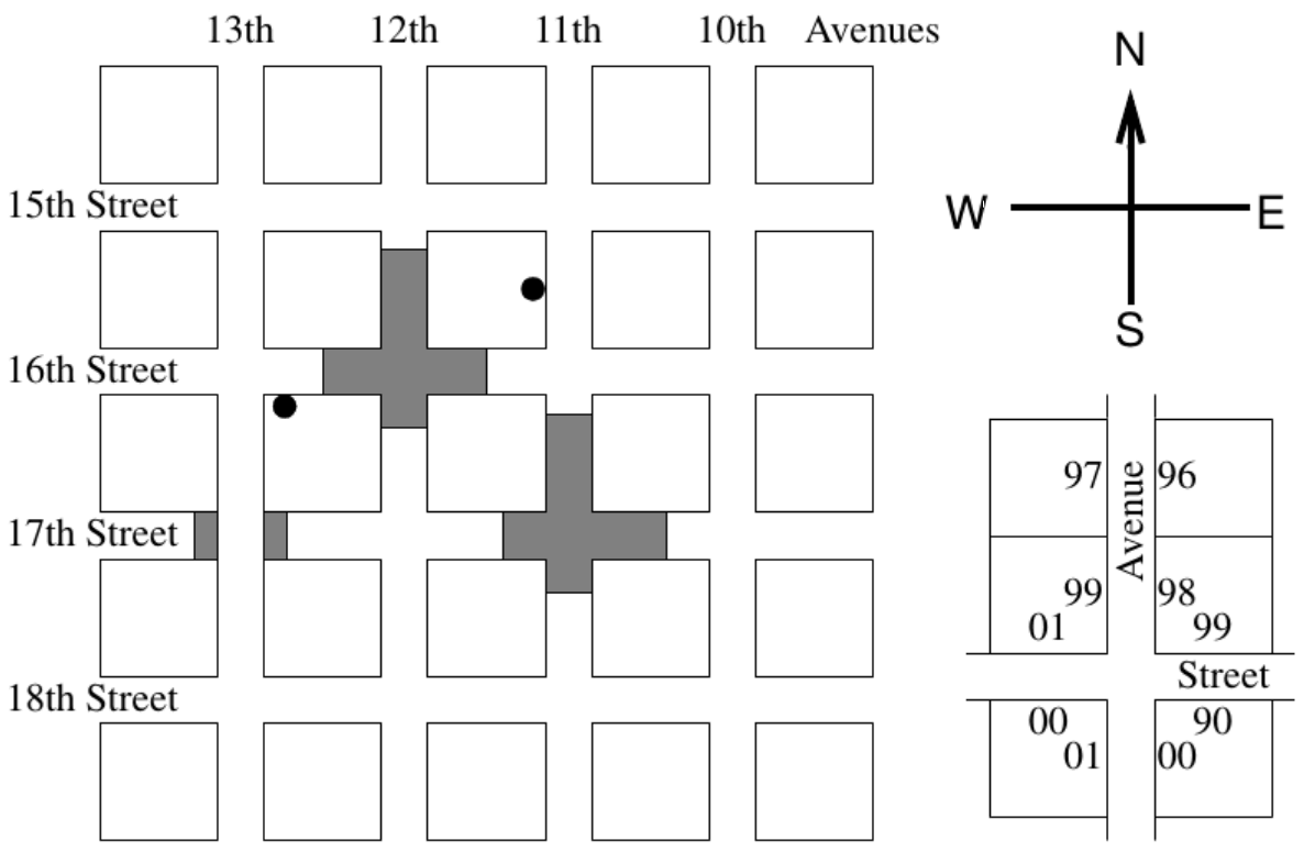
조용한 주택가는 애비뉴와 스트리트 일부를 끊어 놓는 간단한 방법으로 만든다. 지도에서 보듯이 중간이 끊긴 자리가 있어도 애비뉴와 스트리트는 이름을 그대로 유지한다. 주소만 보면 어디로 가야 하는지 정확히 알 수 있어서 이런 도시에서 길을 잃기는 어렵다. 다만 어느 구간이 끊겼는지 모르면 막다른 길로 들어가 시간을 많이 허비한다.
도시에서 끊긴 구간의 정보를 읽고, 이어서 주소 쌍을 여러 개 읽는 프로그램을 작성하라. 주소는 집이 아니라 진입로 하나를 가리킨다고 본다. 각 주소 쌍마다 규칙을 지키는 경로 중 가장 짧은 경로로 두 진입로 사이의 거리를 구한다. 거리는 달리는 동안 내가 달리는 쪽 도로변에서 지나치는 진입로의 개수이고, 출발 진입로와 도착 진입로는 세지 않는다. 다음을 가정한다.
- 차는 도로의 오른쪽으로 달린다.
- 교차로가 아닌 자리에서는 맞은편 차선을 가로지를 수 없다. 즉 진입로에 들어가거나 진입로에서 나올 때는 반드시 우회전해야 한다.
- 진입로는 각 구획의 한가운데에 있다.
- 유턴은 막다른 길 끝에서만 할 수 있다.
- 스트리트와 애비뉴의 번호는 00번부터 49번까지이고 그 바깥에는 도로가 없다. 다만 가장 바깥 도로에도 양쪽에 진입로가 있다.
- 모퉁이에 걸친 구획에는 진입로가 두 개 있다.
- 어떤 두 진입로 사이에도 경로가 존재한다.
입력
입력은 끊긴 도로 부분과 주소 부분으로 나뉘고, 각 부분은 # 한 글자만 있는 줄로 끝난다.
끊긴 도로 부분의 각 줄에는 도로 식별자 하나와 집 번호 두 개가 있다. 도로 식별자는 애비뉴를 뜻하는 A 또는 스트리트를 뜻하는 S 뒤에 00 이상 49 이하의 번호를 붙인 것이다. 집 번호는 0000 이상 4898 이하의 짝수다. 그 도로에서 두 번호가 있는 자리를 포함해 두 번호 사이의 구간은 통행할 수 없다. 끊긴 자리는 도로를 가로질러 그대로 이어지므로, 1612번을 지날 수 없으면 1613번도 지날 수 없다. 끊긴 구간은 진입로가 아니라 구획의 경계에서 시작해 구획의 경계에서 끝난다. 한 줄의 각 부분은 공백 하나로 구분한다.
주소 부분의 각 줄에는 주소가 두 개 있다. 주소는 도로 식별자 뒤에 0000 이상 4899 이하의 번호를 붙인 것이다. 한 줄의 각 부분은 공백 하나로 구분한다.
출력
주소 부분의 각 줄마다 한 줄씩 출력한다. 각 줄에는 두 진입로 사이의 거리, 즉 지나친 진입로의 개수를 정수 하나로 출력한다.
예제 입력은 위 지도가 그린 도시와 같다. A13과 S17이 교차하는 자리를 눈여겨보라.